Tuesday, February 28, 2012

Blue-footed boobies and beautiful sunsets

Our time in Puerto Lopez is better told in pictures. Basically, it's this really cute beach town on the edge of a national park. The beach is beautiful, the water is the perfect temperature, and the wildlife is awesome. Most of our time was spent hanging out on the beach and enjoying the water and scenery, but we did a few activities as well. One day we went out to Isla de la Plata (which is often referred to as "Poor Man's Galapagos") and saw lots of cool birds, fish and other wildlife. And, on our last day, we went parasailing!
Our first sunset over the bay in Puerto Lopez.
Our second sunset over the bay in Puerto Lopez. I swear the sky turned all the colors of the rainbow.
The most amazing batidos (smoothies)!!! I think I drank one every day we were in Puerot Lopez. They were all made with fresh fruit: pineapple, blackberry, passion fruit... My favorite was a blackberry-passion fruit combo--the waitress thought I was really weird when I ordered it. She asked me about 3 times to confirm that was what I wanted.
On the boat out to Isla de la Plata! We were getting on our boat at the same time that all the fisherman were coming in from their morning catch. That means that the stretch of beach where all the boats are anchored was turned into a gutting station. We saw everything from hammerhead sharks (sad :( ) to every specie of fish imaginable. There was one guy walking up to the shore with a bin full of fish on his head, which the birds were attacking trying to steal the fish they could.
First giant sea turtle spotting! (Prize if you can actually find it in this picture, I swear it's there beneath the water).
Welcome to Isla de la Plata! One cool thing we learned: you can volunteer to save baby sea turtles! The giant sea turtles that we saw swimming around in the ocean lay their eggs on the shore. Then, the volunteers help keep the eggs safe so that more baby sea turtles survive.
A baby blue-footed booby! These birds were the main reason I was so excited for Ecuador. This one is a baby, which is why it's feet are blue-grey and also why it's not scared of people--it has grown up with people walking around the island where it lives. Also, it can't fly yet, hence why it's on the ground. These guys were all over the path where we were hiking. Our guide kept telling us we had to "ask them permission to pass."
The whole island is so green!
An older blue-footed booby, with real blue feet.
After snorkeling off the shore of Isla de la Plata. We saw so many brightly colored fish, eels and sea turtles!
Los Frailes beach, one of the most beautiful beaches I have ever been to. The water was crystal clear, although we still had to be careful with the current (there are some really strong currents off the coast off Ecuador, I definitely got tossed around by the waves a fair number of times.) In addition to the beautiful water, the whole coast was green with white sand.
All along the beach in Puerto Lopez there were bars with hammocks and comfy beach chairs. We enjoyed having a drink with our toes in the sand.
Getting prepared for parasailing! The made sure I was strapped in really well because Maya took a little tumble during her takeoff. The guy who ran the parasailing was from Kentucky, but he had retired to Puerto Lopez. How he decided on Puerto Lopez, Ecuador? Google, I kid you not.
Parasailing up above the bay! It was really relaxing and had great views. Even landing in the water was nice. I swear I saw a sea turtle while I was up in the air.

I basically fell in love with Ecuador while we were there, and I know I will go back sometime during my life. It's just such a beautiful country and the people are really nice. I think Puerto Lopez was one of my favorite places during my vacation thus far.

Guayaquil: where pigeons and iguanas frolick together in the plaza

Our first stop in Ecuador was a brief stay over in Guayaquil, the second biggest city in the country. Our bus got in late in the evening, so we decided to spend the night and head out the next morning for Puerto Lopez. While we were in the city, we decided that rather than just holing up in our hotel room we would at least stop by the plaza. We had a heard a lot of rumors that Guayaquil wasn't particularly safe or a particularly nice city. So, we decided to take a cab to the plaza even though it was only 7 blocks away. Although the city itself wasn't super exciting (at least the parts we saw) the plaza was definitely worth the $1.50 cab ride.
As we were asking for directions to the plaza, the concierge referred to as "Plaza de las Iguanas." I didn't understand what he meant until we got there...
Here are some photos from our brief time. (in reverse order, sorry).
The biggest bus terminal I have ever been it. It was three stories tall, complete with shopping mall, grocery store, several banks, as well as ticket offices. When we first pulling in the night before, I was in awe. It was right next door to the airport, and I'm pretty sure the bus terminal was bigger than the airport, I'm not kidding. Apparently they just rebuilt it a few years ago; before it was rebuilt and they had new security and everything, supposedly it was really dangerous, but now it's okay. You didn't even have to pay to go to the bathroom...and it was clean!
One of the, literally, hundred iguanas wandering around the square. They were all different shapes and sizes and colors. When we first got to the plaza, I was looking at the church and Maya came up me and told me "I just saw an iguana in the square!" I thought that as pretty cool, so I went over to try and see the iguana she had seen, only for both of us to realize that the ENTIRE plaza was filled with iguanas roaming around.
In addition to iguanas wandering around, there were turtles and fish swimming in the pond and pigeons eating out of peoples hands (I personally would never let a pigeon that close to me). It was kind of like an outdoor mini-zoo or something.
The main cathedral (and a statue of someone who I can't remember, most like the person who helped Ecuador get there freedom, they usually get a statue in the main plaza). The church was really beautiful both inside and out.

Wednesday, February 22, 2012

Huaca (huaca hey, hey)


(For those who don't get the above reference, Shakira sings a song called Waka Waka which she made for the 2011 World Cup, the name of the pyramids are pronounced the same as her song. You can listen to the song here, if you feel so inspired: http://www.youtube.com/watch?v=pRpeEdMmmQ0 it's actually pretty good, in my opinion). The day after Chan Chan we headed to some more ruins: La Huaca del Sol y La Huaca de la Luna. As far as I can tell, "huaca" means the same things as "pyramid and/or temple," although I am sure there is some difference. (Here's the definition according to Wikipedia: In Quechua, a Native American language of South America, a huaca orwaqa is an object that represents something revered, typically a monument of some kind. The term huaca can refer to natural locations, such as immense rocks. Some huacas have been associated with veneration and ritual. Andean cultures believed every object has a physical presence and two camaquen (spirits), one to create it & another to animate it. They would invoke its spirits for the object to function.) Oh, and sol=sun and luna=moon.
Anyways, both of the Huacas were really impressive. The Huacas were constructed by the Moche civilization between 100BC-800AD. This part of their civilization consisted of two large pyramids (the Huacas) with a residential area located in between the two. La Huaca de la Luna was built against a mountain, and eventually, (with all the layers) ended up essentially being built into the mountain. La Huaca del Sol is located opposite the Huaca de la Luna, with the houses in between. Over they years, they would decide to build a new layer of the huaca over the whole huaca, creating a "new huaca". Once a new layer was constructed, it was not possible to access the previous layers.
Thus far, they have only excavated the inside of Huaca de la Luna. We got to take a tour and see the inside of the huaca, which was awesome. Huaca de la Luna is the smaller of the two, but they think that it was the more important one religiously. It is comprised of 5 layers-back in the day, it was only possible to go on the outermost layer. Now, however, various layers are excavated and we got to see a little peek from the third all the way up to the fifth layers. Each layer has the same basic plan, just with the rooms in different places.
My favorite part of the huaca were the paintings. There are different designs all around the inside and outside-and the are all original, including the colors. It was so cool to see paintings that were made 2000 years ago and are still in pristine condition.
Okay, so here are a few tidbits from the day :)
This is the room where the would prepare prisoners (and other people) for sacrifice. This was the first part of the Huaca we saw.
The big, natural rock is the sacrificial rock. Yes, back in the day, they sacrificed people there. The rock was a natural part of the mountain, they didn't put it there, they just decided it would make a good sacrificial place. Initially, the rock was up behind the Huaca. However, as the Huaca expanded and kept getting built onto, the rock became sort of incorporated into the Huaca. It was never in the middle of the Huaca, rather at the back of it by the 4th and 5th layers. Unlike the Mayas and Aztecs, when the Moche sacrificed people, only the important religious figures were allowed. It was not a town event. After the sacrifice, however, the priest would bring the blood of the sacrificee out in a cup for all to see.
One of the well preserved paintings. According to our guide, they have not doing anything to restore it. It is some sort of feline-looking figure because felines were considered to be divine. You can clearly see the colors of red, yellow, black and white.
This the residential sector, located in between the two Huacas. I think it looks like a model in this picture, but it's the real deal! Archaeology students from one of the local universities get to come and excavate it...pretty cool! They still have not excavated very much of the residential section, but it is a work in progress.
The main plaza of la Huaca de la Luna. The opening in the top of the Huaca is where the priest would come out to show the cup of blood to the village. Everyone would gather in the plaza where I am standing to watch. On the wall is painted a hierarchy of the society: prisoners on the bottom, then workers (if I remember correctly), spiders, a feline figure, and finally the snake up at the top.
Align Center
Another really cool painting, even more well preserved than the other one.
Welcome to the Huacas de Moche!

After our visit to the Huacas, we spent the rest of the afternoon in Trujillo people watching, enjoying the beach and killing time until our bus to Piura (and then Guayaquil, Ecuador) that night. These pictures are in reverse order...sorry
On the bus from Piura, Peru to Guayaquil, Ecuador. A beautiful sunset over a banana farm in Ecuador. I was amazed at the colors in the sky and how green everything was.
Crossing the border! Welcome to Ecuador!
The sexiest bus outfit you ever did see. The Cruz del Sur bus terminal was really nice, they checked our luggage in and everything, just like an airport. And, the bus was by far the nicest I have been on in Peru. It was just as nice or nicer than the ones I take in Chile. Too bad the direct to Guayaquil was already sold out :(
The famous reed boats in Huanchaco. Apparently the fisherman have built and used them for thousands of years. The go out early in the morning and in the late afternoon to get the days catch. It's quite impressive to watch them tackle the waves in their little tiny reed boats, just perched on top.
A beautiful sunset off the coast of Huanchaco. The balcony from our hostel overlooked this view. And we could hear the waves from our room as we fell asleep.

Friday, February 17, 2012

Chan Chan: The largest adobe city in the world

On the day after we arrived in Trujillo/Huanchaco, we decided to go to Chan Chan (more ruins! and one of our main reasons for stopping in that area). It is (or was?) the largest adobe city in the world, built by the Chimu culture. You can see how expansive just the ruins that are left are from driving by on the road. Only a very small part of it has been restored, and, according to all of the tour books it's not a good idea to go wandering around the other parts of the site because there have been reports of "violent attacks on tourists." So, Maya and I decided to stay in just the part that was restored and had security guards. When we first arrived in the morning, the site was still closed because it had rained the night before (this causes the walls to essentially melt sine they are made of dirt). They told us, however, that it would open in up in about hour. So, to kill time we went into Trujillo to get bus tickets for Guayaquil (which ended up being sold out the day we wanted to go with the company we wanted to go with, so we just got tickets with that company to Piura where the plan was to change buses for one up to Guayaquil). When we came back, the site was open (oh yes, we also had to take the $5 dollar taxi instead of the 50 cent bus because the tour books say not to walk along the road unless you are in a big group, because, again, there have been reports of attacks on tourists...get your stuff together Peru!!) Anyways, we decided our safety was worth the extra couple dollars. To get from the highway to the restored part of the ruins you drive through the rest of the city which as not been restored. It seems like there are adobe walls that go on FOREVER. And, considering the whole thing is made out of mud, it's quite impressive how much of it has stood the test of time and rain and everything else that has been thrown at it (it was constructed around 850 AD and was the largest pre-colombian city in South America). At it's high point, around 60,000 people lived in the city...that's a lot for a mud city!
Here's some picture's from the day:
The melting wall of the city after the rain :( You're not really allowed to touch everything for fear that it will crumble. I'm guessing children were discouraged from having waterfights back in the day...
Apparently every time it rains they just try and through tarps over the part of the city that has been restored. Then, when the rain passes, the walk around with a bag of dirt to restore the parts that have been ruined.
Random lake in the middle of the city. Apparently after the city was abandoned, they used this area for leaving offerings for the gods. (I'm a little unclear about whether there was always a lake or not).
A room where they think that kept statues of their gods and also left them offerings.
The fish signs that guided us through our self guided tour of the city. follow the yellow fish-sign...
Maya and I are guessing that these were probably houses, although they didn't have a sign to clarify for us. There were a bunch of little square boxes that all looked the same. And, in the background, you can see the really tall wall that ran around the whole city.
I can't believe they made so much stuff out of mud! It's crazy. It also seems slightly impractical, although I guess since we're still looking at it 1200 years later, it wasn't such a bad idea after all. The whole city was like a labyrinth, because you couldn't see over any of the walls. I don't understand how people didn't get lost back in the day, they didn't have those nice little yellow fish signs to guide them through the city...
Some really cool designs they carved into the wall. The fish are supposed to be in the shape of ocean waves. Their culture depended a lot on the ocean for nutrients, so they would make offerings and carve designs about it to bring them good luck and food.
A guy wandering around dressed in "period" dress like the nobility. They would wear gold plated shirts, headresses, necklaces, nose pieces, earings...etc.
The main plaza. The nobility would stand up at the front under a little shade structure. (The awnings that are there now are not a representation, theyre just there to help protect the walls and carvings from the rain.)
Welcome to Chan Chan archeolgical site!

Tuesday, February 14, 2012

Thousands year old gruesome battle scenes

After Huaraz, we headed back to Peru's coast, and thus, the desert. I have to say, going to Peru, I thought the coast line was going to be more tropically, like it is up here in Ecuador. I guess that's my own fault for being ignorant and not doing my research before heading on my journey. Anyways, I guess it makes for lots of cool, preserved ruins. Of course, what did Maya and I do but go see more ruins? :) This time it was just a small religious site; it seemed tiny in comparison to the other ruins we had been visiting. I'm not sure which culture used it (I'm not sure if the archaeologists know), but it is most famous for the gruesome battle scene that is depicted on the outside wall of the main structure. There was also a small museum at the site that had some artifacts found at the site on display and a limited amount of information about the site available.
We arrived there by mototaxi (a three wheeled taxi called a tuk tuk in Guatemala and a rickshaw in India). It was only about 5km out of town, but we had to drive down the side of the road since the mototaxi didn't go very fast, it was kind of funny. On the way back, one of the guards from the site took us home. He just went and grabbed one of the many mototaxi they had laying around and took us back into town.
The site, as I said before, was really small, but I'm still glad we went to go see it.
A creepy, ugly, hairless dog of Peru. For some reason, these guys are all over the towns in northern Peru. But they're always peoples pets, not the stray ones roaming around. They're really ugly, but really fascinating at the same time. What kind of dog doesn't have hair??
One of many heads depicted on the wall. Apparently, all the heads that were just floating on the wall were supposed to be people who had been decapitated during battle. This one is spewing blood from i t's mouth.

Some people still had bodies. I assume they were the victorious ones in battle. I think this guy most be nobility, or at least someone important, since he has a headdress and walking stick/weapon thing in his hand.
That little square down below me...that's the whole site. It was so tiny! It seemed so small compared to everything else we had seen. But when we got up close and could see the carvings in the walls it seemed pretty impressive.
A (recreation?) of a sculpture they found at the site.
Mummy in the museum. With a really, really scary expression on her face. It said they thought she was asphyxiated.

Wednesday, February 8, 2012

Huaraz: Walking Inside Pyramid's and Hiking to the Heaven's

After leaving Barranca and Caral, we headed to back to the cordillera (mountains) of Peru. In my opinion, the cordillera of Peru is a lot more beautiful than the coast. The whole coastline is desert, and I'm not really a desert person. The cordillera, however, the area surrounding it is green, with snow capped mountains...beautiful every direction you look.
We took a colectivo (shared taxi) over the mountains because it was safer and faster than buses. It was fun to watch the scenery change as we got closer to the cordillera, from a desert landscape to green hills to a backdrop of the Andes. The town itself was fine--the third biggest city in Peru and a major launching point for outdoor excursions (although since it's rainy season, there are a lot less people than during the dry season). The one good thing about it being a tourist hub? Lots of good food to choose from. I like Peruvian cuisine a lot, but it was nice to take a break and have some things like curry and salad. (Okay note: I had expected the vegetable situation to be the same in Peru as it had been in Central America--boil or peel. However, it turns out you can actually drink the water in Lima, and the water and vegetables are not as "dangerous" here as in central America. Another words, you still need to use you best judgement in where to eat, but in general you can actually eat a salad and other veggies and not worry about getting some really bad parasite because of doing so.)
Anyways, on our first day we just wandered around the town and took in the sights and enjoyed the food. The next morning we got up to go to Chavin de Huantar--a famous religious sight (sort of) near Huaraz. It actually ended up being about a 3 hour drive each way, but we got to go inside of the pyramid at the site which was AWESOME. The actual ruins themselves were a lot less impressive than some we had seen previously, but the fact that we got to go inside of the pyramid was just really cool.
The day after that we got up really early (5:30....) to got on a hike up in the mountains. We were originally planning on taking colectivos, because it was a lot cheaper than going with a tourist agency. But as we were waiting for the colectivos, a tourist van pulled up that had some extra spots and offered to take us for only s./10 more than it would have been in a colectivo, so we decided to go. The hike was one of the most beautiful and most challenging hikes I have ever been on. We started at a little below 12,000 feet (3,900 meters) and climbed up to about 14,500 feet (4,700 meters)--so the altitude definitely added to the difficultly of the hike.
I had trouble picking pictures, so there are a lot from the couple of days :)
Delicious, fresh mango juice at one of the cafe's in Huaraz. Also, (this is for you Mom, because I tried to show you over skype and it didn't work) a really nice, warm alpaca shawl :)
Maya and I at one of the lakes on the way to Chavin. The drive on the way there didn't seem to take too long. We got to stop and see this lake, which was pretty, as well as some other fun things along the way. The drive back, however, seemed to take forever. This road was probably the worst we went on in Peru. I don't think it's used very often, so they don't maintain it a whole lot...there are potholes everywhere, meaning they can't drive more than like 10 mph (or so it seemed) for fear of running into one. The upside of the drive home: a beautiful sunset in the altiplano (this lake is at 4,000+ meters, about 12,000+ feet)
This is the front of the pyramid at Chavin de Huantar. It was a religious site for Chavin culture. If I remember correctly from the sign in front, it was built between 100-800 BC (I could be a little off on my dates). In any case, the priests would go inside the pyramid (where only people of a certain standing were allowed in) and smoke San Pedro Cactus to be closer to the gods and have visions. Later, they would carve what they had seen during their "visions" into stone tablets. Hence, there are lots of really cool, slightly creepy carvings from Chavin.
In front of the main entry way to the outside of the pyramid. The interior pillars are intricately carved: one side is a woman, which at one point was white and is supposed to represent the good; the other side is a man, and was black, and is supposed to represent the bad. (All the old culture's in Peru were all about duality and having equality and two of everything to balance out).
Chavin has a really complex system of underground canals that brought water to the site. Our guide was also saying something about the priests walking in the canals, which confused me, because if they are full of water...how can the priests walk in them? Anyways, they run throughout the entire site.
Inside the pyramid. This was by far my favorite part. It was a whole intricate labyrinth of hallways and dead ends throughout the entire pyramid. There were windows looking between the rooms, and, every once in a while, you could see a "ventilation" window with a little sliver of natural light peeking through.
Being a bad tourist and taking pictures of locals...but her hat and cape are just so cool. All the locals would tie clothes around their shoulders to protect them from the rain. Plus, the river and background are really pretty too.
An intricately carved conch shell that they found at Chavin.
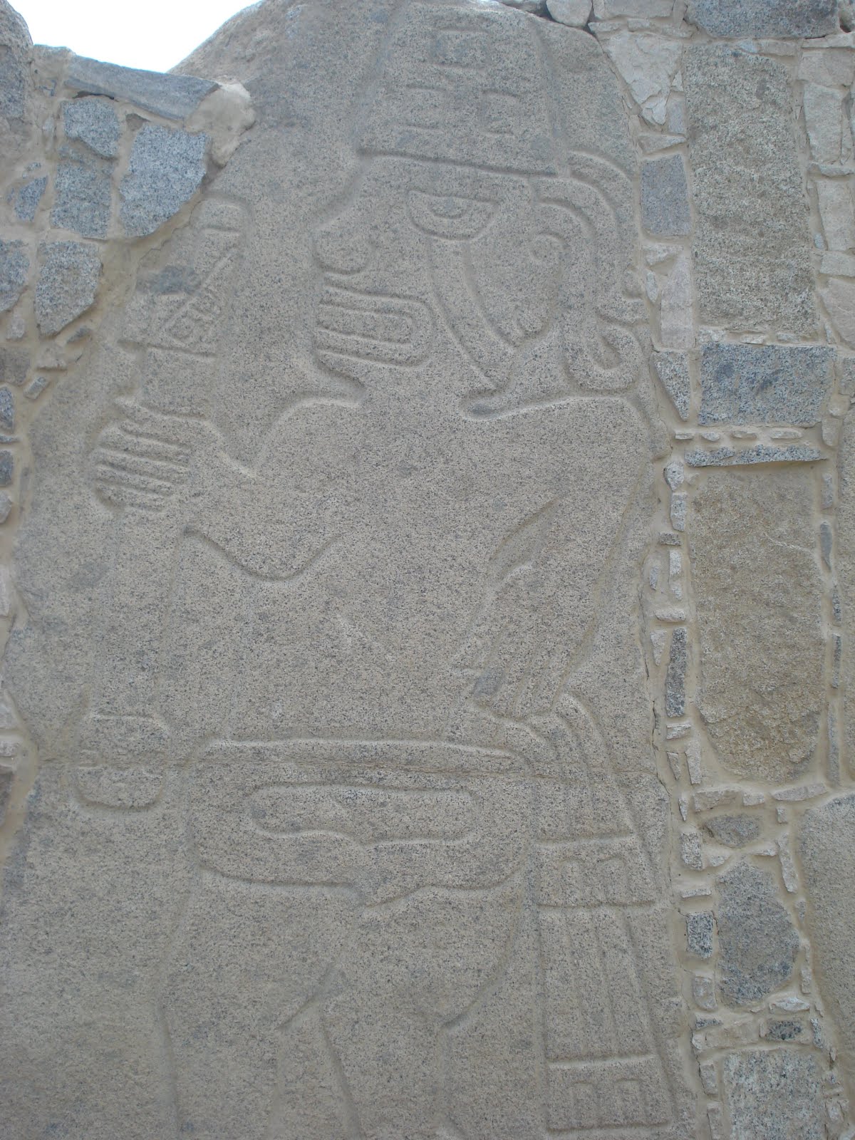
One of the many interestingly carved stone tablets found at the site. I wonder WHAT exactly it was they were seeing. If those were the kind of visions I had, I think I would be pretty scared.
Back in the day, the pyramid at Chavin was covered in these heads. The Chavin culture (along with a lot of other pre-Colombian cultures) thought the feline was sacred animal. Thus, many of their divine creatures, and depictions of priests, have feline-like characteristics.
The sunset over the altiplano on the way home.
The next morning, bright and early, on our drive up the mountain. We first had to drive about 2.5 hours to even arrive at the trail head. This was one of the lakes we passed along the way. There was a group of three of them name: Mom lake, Dad lake, and baby lake (or something to that effect). The water was so turquoise and beautifully blue. The fog that was surrounding the lake just made it look that much more mysterious.
Some Andean geese in swimming in the lake. And, though it's kind of hard to see in this picture, the black bird swimming along side them has a bright blue beak! About the same color as the water...
One of many waterfalls we saw along our hike. The two main ones were named "big waterfall" and "small waterfall". We knew we were on the right track when we passed in between them. (We had a very professionally drawn hand map...saracastic, in case you can't tell, we got lost several times on the trek). We basically hiked from the bottom of this waterfall up to the top.
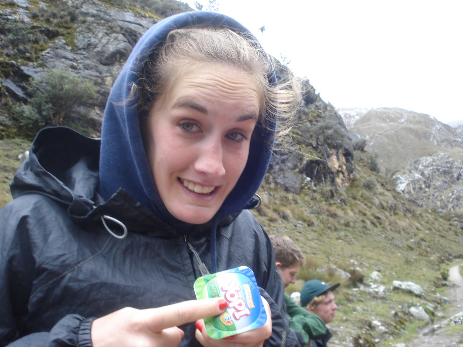
My extremely puffed up yogurt from going up in altitude. I could definitely feel the altitude as we went up as well. I felt like my head was expanding just like my yogurt lid... A couple of the girls actually ended up having to turn around because they got so sick from the altitude. Maya and I could both feel it quite a bit, but we both really wanted to make it up the mountain, so we pushed through. Later on that night, however, our bodies protested for putting them through so much stress.
The whole group at our destination, Lake 69. How it received that name? I have no idea, but I would like to find out. It was one of the most beautiful lakes I had ever been to. As you can see from the photo, it is a perfect blue color. There were two waterfalls on either side cascading down into the lake. Up on top was a glacier (glacier, not iceburg Mom ;), hence I think the lake is made from glacier melt, giving it that perfect blue color (that's just my guess, I'm not positive)
You can see the beautiful contrast between the green plant and the blue water. Of course, it started to rain on us on our way down the mountain...
The path turned into a waterfall. Although it is a bit hard to tell in this picture, we were basically wading through water. Although the hike was extremely rewarding, and the views were spectacular, I think everyone was happy to make it back to the car and ride the rest of the way back to Huaraz.
Coming up next: more ruins in Casma/Sechin, Chan Chan and Huacas del Sol y la Luna. The beach at Huancahco and finally...Ecuador!! This is picture of one of the rock slides on the road from Huaraz to Casma. Luckily, there were no rock slides while we were driving and we had a good driver who drove very carefully around them.

*correction from my last blog. Caral was city 5000 years before present, aka 3000 BC. Likewise for Mesopetamia and Egypt, I got my dates a little mixed up. Also, I would like to point out that following the diagram I read at Sechin, modern humans evolved 40,000 years ago. That means it took them 35,000 years to actually build anything that lasted until present day...that's a really long time!

Anyways, Huaraz was beautiful. We had wanted to go on another hike the day after Lake 69 but were both so dead tired after the previous day's hike that we just decided to head to Casma. I have to say...while I love the mountains, it's nice to be at sea level again.